The Geological Service for Europe (GSE), once established, will be a key player in facilitating these efforts by providing comprehensive, high-quality subsurface data and advanced geoscientific expertise.
The GSE will offer a centralized repository of subsurface data via its knowledge hub EGDI (European Geological Data Infrastructure), making it accessible to commercial entities, regulators, and the public, which will streamline regulatory approvals and promote a faster rollout of renewable energy infrastructure.
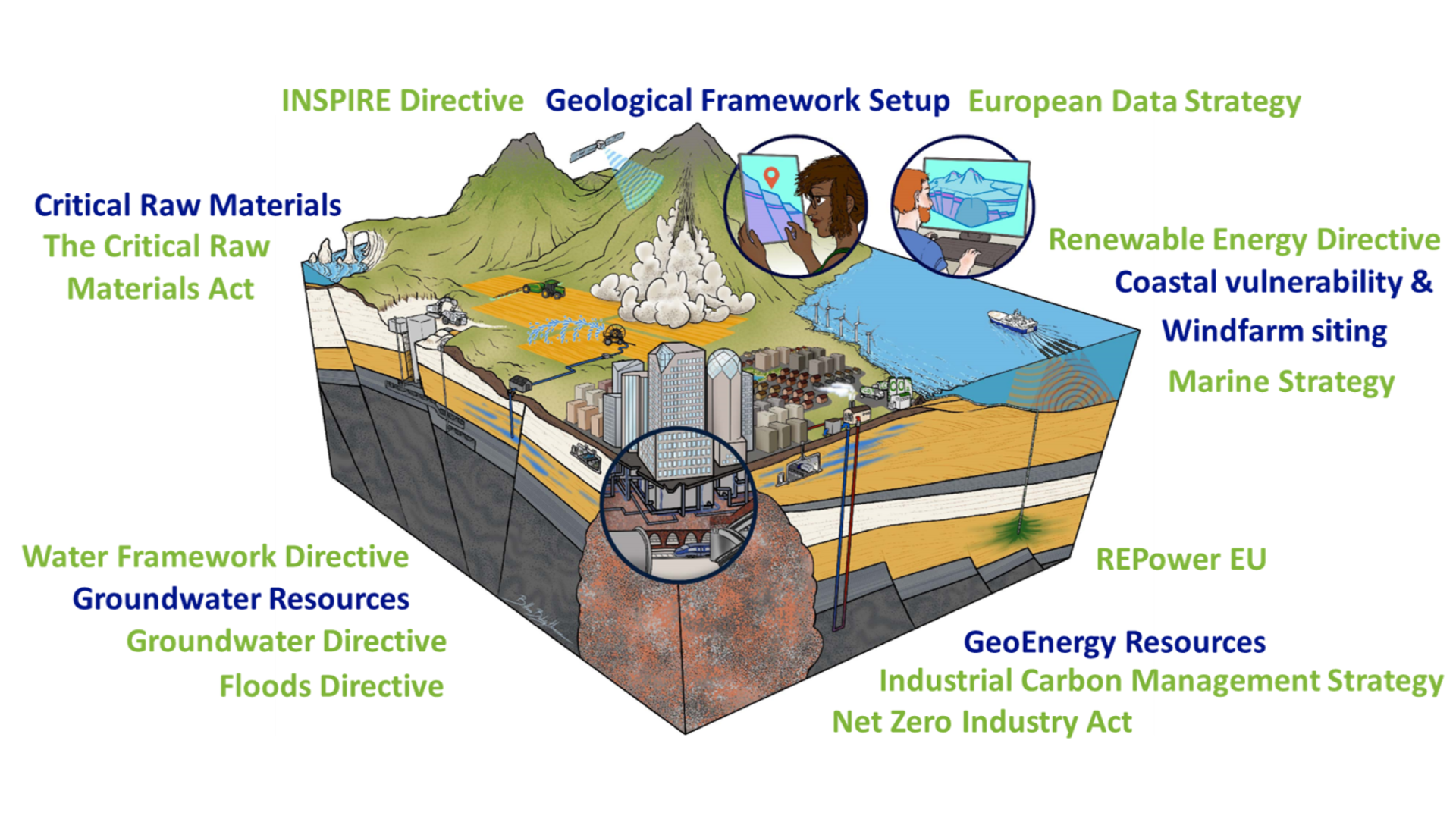
Figure: Green Deal Policy & Earth Systems are Interconnected
Enhancing Renewable Energy Development
Subsurface data is critical for identifying suitable locations for renewable energy projects such as geothermal, wind and energy storage (especially hydrogen) installations. This ensures that renewable energy sources are developed in the most optimal and sustainable manner, maximizing efficiency while minimizing environmental impacts. By accurately mapping the subsurface, we can significantly improve the site selection process for renewable energy areas, ensuring that these areas are not only viable but also exploited in a sustainable manner.
Accurate geological surveys and data are the starting point for the identification of the most suitable locations for renewable energy installations, ensuring that these areas are sustainably and efficiently utilized. This is crucial for optimizing subsurface (and land) use and ensuring that renewable energy projects do not conflict with other development or environmental conservation efforts.
Supporting the Pre-Permit Phase
High quality pan-European subsurface data will support the pre-permit phase of renewable energy, energy storage and CCS projects. For example, characterizing potential CCS European sites with porosity, permeability, seal integrity, storage capacity and geochemical interactions it is the foundation of a pan-European carbon storage system.
By providing precise geological data early in the planning process, we can reduce uncertainties and risks and expedite policy and investment decision-making.
Sustainable Exploitation of Resources
Ensuring the sustainable exploitation of renewable energy resources involves understanding the geological context to prevent adverse environmental impacts. The GSE and EGDI will play a vital role in this by:
- Using subsurface data to predict and mitigate environmental impacts (e.g. on groundwater resources)
- Providing guidelines and frameworks for sustainable resource exploitation (e.g. by supporting a pan-European implementation of the United Nations Framework Classification for Resources, UNFC)
Attracting International Investors
Comprehensive and reliable subsurface data and geoscientific knowledge will be the basis of independent advice for a broad range (public and private) stakeholder. This is a very valuable asset that can attract international investment. Investors seek certainties and reduced risks: high-quality subsurface data provides the confidence needed for significant investments in renewable energy projects.
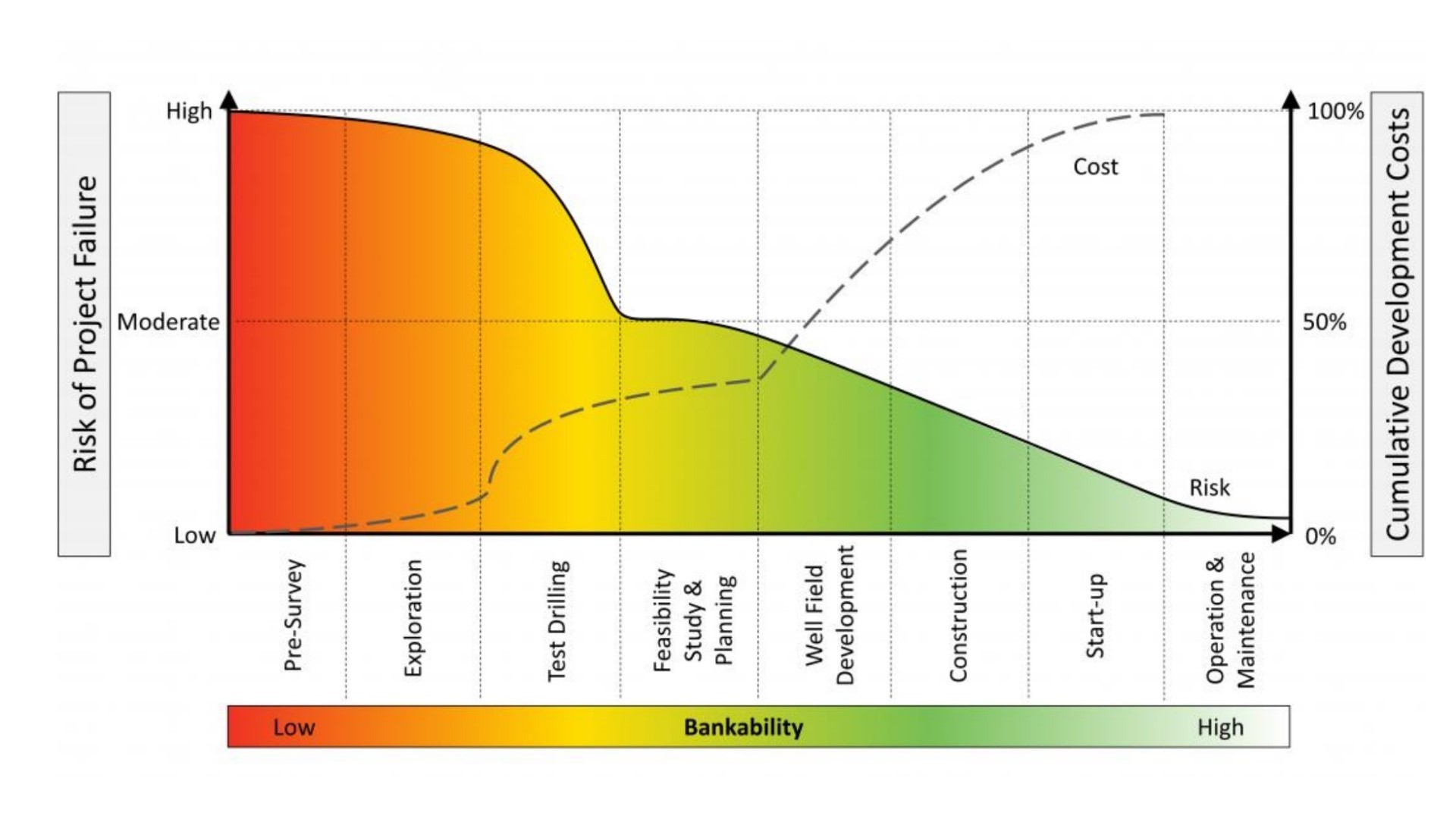
Figure: Geothermal risks and costs (Tharom and Hadi, 2020)
The GSE will serve as an example of transparency and reliability, showcasing European commitment to robust, data-driven project planning and execution. This will not only attract financial investments but also foster partnerships and collaborations with global stakeholders.
Conclusion
The establishment of the Geological Service for Europe will mark a significant step towards achieving the EU's Green Deal and net-zero targets. By providing high-quality subsurface data and geoscientific expertise, we can ensure the efficient and sustainable large-scale deployment of renewable energy projects, streamlining the pre-permit phase, attracting investors, and properly designating and sustainably exploiting renewables acceleration areas. This initiative underscores the importance of leveraging geological data to support the EU's transition to a long term sustainable and climate change resilient energy system.
Back